![Canyons of the Escalante [Grand Staircase-Escalante National Monument] National Geographic Maps Author](https://images.eurobuch.ch/buch/cover/OTc4MTU2Njk1MzI0NTtodHRwczovL3Byb2RpbWFnZS5iYXJuZXNhbmRub2JsZS5jb20vcGltYWdlcy85NzgxNTY2OTUzMjQ1X3AwX3YyX3MxOTJ4MzAwLmpwZw%3D%3D.jpg)
ISBN: 9781566953245
• Waterproof • Tear-Resistant • Topographic MapAt over 1.7 million acres, Grand Staircase-Escalante National Monument encompasses the largest land area of all national monu… Altro …
| BarnesandNoble.com new in stock. Costi di spedizione:zzgl. Versandkosten., Costi di spedizione aggiuntivi Details... |
![Canyons of the Escalante Map [Grand Staircase-Escalante National Monument] (National Geographic Trails Illustrated Map, 710) - National Geographic Maps](https://images.eurobuch.ch/buch/cover/OTc4MTU2Njk1MzI0NTtodHRwczovL2ltYWdlcy5ldXJvYnVjaC5jaC9pbWFnZXMvaXQvcGFydHMvY292ZXJfdmVyZ3JpZmZlbi5wbmc%3D.png)
Canyons of the Escalante Map [Grand Staircase-Escalante National Monument] (National Geographic Trails Illustrated Map, 710) - copertina rigida, flessible
2010, ISBN: 9781566953245
Rand McNally, Chicago. Story of a gentled but independent burro whose regular travels from Bright Angel Creek to the Kaibab Forest became an official trail. Includes two prospectors (on… Altro …
| usa, u.. | Biblio.co.uk |
![Canyons of the Escalante Map [Grand Staircase-Escalante National Monument]](https://images.eurobuch.ch/buch/cover/OTc4MTU2Njk1MzI0NTtodHRwczovL2NvdmVyczIuYm9va3NhbWlsbGlvbi5jb20vY292ZXJzL2JhbS8xLzU2LzY5NS8zMjQvMTU2Njk1MzI0My5qcGc%3D.jpg)
ISBN: 9781566953245
Find Canyons of the Escalante Map [Grand Staircase-Escalante National Monument] by National Geographic Maps in Map and other formats in Travel > Maps & Road Atlases. Travel 9781566953245… Altro …
| Booksamillion.com new in stock. Costi di spedizione:zzgl. Versandkosten., Costi di spedizione aggiuntivi Details... |
National Geographic Canyons of the Escalante Trails Illustrated Map: Grand Staircase - Escalante NM - nuovo libro
2010, ISBN: 9781566953245
Natl Geographic Society Maps, 2010. Map. New. map edition. 2 pages. 0.25x9.25x4.25 inches., Natl Geographic Society Maps, 2010, 6
| Biblio.co.uk |

2012, ISBN: 9781566953245
Trails Illustrated Other Rec. Areas, Karte/Globus, Karte (gefalzt), 2010th ed. [PU: National Geographic Maps], National Geographic Maps, 2012
| lehmanns.de Costi di spedizione:Versand in 7-10 Tagen. (EUR 0.00) Details... |

![Canyons of the Escalante [Grand Staircase-Escalante National Monument] National Geographic Maps Author](https://prodimage.barnesandnoble.com/pimages/9781566953245_p0_v2_s192x300.jpg)
Canyons of the Escalante [Grand Staircase-Escalante National Monument] National Geographic Maps Author - nuovo libro
ISBN: 9781566953245
• Waterproof • Tear-Resistant • Topographic MapAt over 1.7 million acres, Grand Staircase-Escalante National Monument encompasses the largest land area of all national monu… Altro …

National Geographic Maps:
Canyons of the Escalante Map [Grand Staircase-Escalante National Monument] (National Geographic Trails Illustrated Map, 710) - copertina rigida, flessible2010, ISBN: 9781566953245
Rand McNally, Chicago. Story of a gentled but independent burro whose regular travels from Bright Angel Creek to the Kaibab Forest became an official trail. Includes two prospectors (on… Altro …
![Canyons of the Escalante Map [Grand Staircase-Escalante National Monument]](https://covers2.booksamillion.com/covers/bam/1/56/695/324/1566953243.jpg)
ISBN: 9781566953245
Find Canyons of the Escalante Map [Grand Staircase-Escalante National Monument] by National Geographic Maps in Map and other formats in Travel > Maps & Road Atlases. Travel 9781566953245… Altro …
2012, ISBN: 9781566953245
Trails Illustrated Other Rec. Areas, Karte/Globus, Karte (gefalzt), 2010th ed. [PU: National Geographic Maps], National Geographic Maps, 2012
Dati bibliografici del miglior libro corrispondente
![Canyons of the Escalante [Grand Staircase-Escalante National Monument] National Geographic Maps Author](https://www.lehmanns.de/media/32873061)
| Autore: | |
| Titolo: | |
| ISBN: |
• Waterproof • Tear-Resistant • Topographic Map
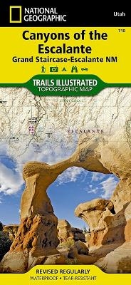
At over 1.7 million acres, Grand Staircase–Escalante National Monument encompasses the largest land area of all national monuments in the United States. National Geographic’s Trails Illustrated map of Canyons of the Escalante delivers unmatched detail and valuable information to assist you in your exploration of this remote and colorful wilderness. Expertly researched and created in partnership with local land management agencies, this map features key points of interest including Fiftymile Bench, Escalante Petrified Forest State Park, Anasazi State Park Museum, and Horse Canyon.
Hiking route summaries will guide you off the beaten path and back again and high clearance and four-wheel-drive roads are clearly marked to keep you out of trouble. River mileage on the Escalante River is noted as well, for those exploring the canyons by boat. The map base includes contour lines and elevations for summits. Recreation features include campgrounds, trailheads, picnic areas, points of interest, fishing access, and boat launches.
Every Trails Illustrated map is printed on "Backcountry Tough" waterproof, tear-resistant paper. A full UTM grid is printed on the map to aid with GPS navigation.
Other features found on this map include: Box-Death Hollow Wilderness, Capitol Reef National Park, Circle Cliffs, Dixie National Forest, Escalante River, Fiftymile Mountain, Glen Canyon National Recreation Area, San Juan River, Smoky Mountain, Straight Cliffs.
Map Scale = 1:75,000Sheet Size = 37.75" x 25.5"Folded Size = 4.25" xInformazioni dettagliate del libro - Canyons of the Escalante [Grand Staircase-Escalante National Monument] National Geographic Maps Author
EAN (ISBN-13): 9781566953245
ISBN (ISBN-10): 1566953243
Copertina rigida
Copertina flessibile
Anno di pubblicazione: 2010
Editore: National Geographic Maps Core >9
Libro nella banca dati dal 2014-02-09T00:25:10+01:00 (Zurich)
Pagina di dettaglio ultima modifica in 2024-03-16T22:05:22+01:00 (Zurich)
ISBN/EAN: 9781566953245
ISBN - Stili di scrittura alternativi:
1-56695-324-3, 978-1-56695-324-5
Stili di scrittura alternativi e concetti di ricerca simili:
Autore del libro : yes illustrated, mcnally rand, national geographic maps, created united states national museum
Titolo del libro: geographic national, stair, 710, staircase, gran canyon, illustrated illustrated, grand canyon, map, trail, monument
Altri libri che potrebbero essere simili a questo:
Ultimo libro simile:
0749717017108 Escalante Canyons: National Geographic Trails Illustrated Utah: Trails Illustrated Other Rec. Areas (National Geographic Trails Illustrated Map, Band 710) (National Geographic Society (U. S.))
- 0749717017108 Escalante Canyons: National Geographic Trails Illustrated Utah: Trails Illustrated Other Rec. Areas (National Geographic Trails Illustrated Map, Band 710) (National Geographic Society (U. S.))
- 0749717009974 Bryce Canyon National Park: Trails Illustrated - NP 219 (GPS Compatible) (National Geographic Maps)
- 0749717009905 Acadia National Park, ME: National Geographic Trails Illustrated USA Nordosten: Outdoor Recreation Map. Isle Au Haut, Mount Desert Island, and ... Geographic Trails Illustrated Map, Band 212) (National Geographic Maps)
< Per archiviare...