
ISBN: 9781566954105
• Waterproof • Tear-Resistant • Topographic MapLocated just off the California shore, the Channel Islands are home to many unique species of flora and fauna. National Geogr… Altro …
| BarnesandNoble.com new in stock. Costi di spedizione:zzgl. Versandkosten., Costi di spedizione aggiuntivi Details... |

ISBN: 9781566954105
National Geographic's Trails Illustrated Maps are the most detailed and up-to-date topographic recreation maps available for US National Parks, National Forests and other popular outdoor … Altro …
| wordery.com Nr. 9781566954105. Costi di spedizione:, , zzgl. Versandkosten., Costi di spedizione aggiuntivi Details... |

2012, ISBN: 9781566954105
Trails Illustrated National Parks, Karte/Globus, Karte (gefalzt), 2019th ed. [PU: National Geographic Maps], National Geographic Maps, 2012
| lehmanns.de Costi di spedizione:Versand in 7-10 Tagen. (EUR 0.00) Details... |

2012, ISBN: 9781566954105
Books National Geographic Maps|Sheet map, folded|National Geographic Maps|02/08/2012, National Geographic Maps
| Waterstones.com Nr. 9781566954105. Costi di spedizione:, , zzgl. Versandkosten., Costi di spedizione aggiuntivi Details... |

2012, ISBN: 9781566954105
Trails Illustrated National Parks, 2006th ed., Karte (gefalzt), Karte/Globus, [PU: National Geographic Maps]
| lehmanns.de Costi di spedizione:Versand in 7-10 Tagen, , Versandkostenfrei innerhalb der BRD. (EUR 0.00) Details... |

ISBN: 9781566954105
• Waterproof • Tear-Resistant • Topographic MapLocated just off the California shore, the Channel Islands are home to many unique species of flora and fauna. National Geogr… Altro …


ISBN: 9781566954105
National Geographic's Trails Illustrated Maps are the most detailed and up-to-date topographic recreation maps available for US National Parks, National Forests and other popular outdoor … Altro …
2012
ISBN: 9781566954105
Trails Illustrated National Parks, Karte/Globus, Karte (gefalzt), 2019th ed. [PU: National Geographic Maps], National Geographic Maps, 2012

2012, ISBN: 9781566954105
Books National Geographic Maps|Sheet map, folded|National Geographic Maps|02/08/2012, National Geographic Maps
2012, ISBN: 9781566954105
Trails Illustrated National Parks, 2006th ed., Karte (gefalzt), Karte/Globus, [PU: National Geographic Maps]
Dati bibliografici del miglior libro corrispondente

| Autore: | |
| Titolo: | |
| ISBN: |
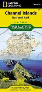
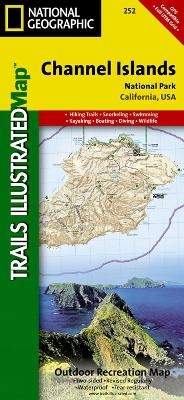
• Waterproof • Tear-Resistant • Topographic Map
Located just off the California shore, the Channel Islands are home to many unique species of flora and fauna. National Geographic’s Trails Illustrated map of Channel Islands National Park covers with unparalleled detail the five islands that encompass the park, including The Nature Conservancy area of Santa Cruz Island and the many State Marine Reserve Areas surrounding the islands. Expertly researched and created in partnership with the National Park Service and others, the map provides background information of the park and of each individual island along with its regulations and guidelines. In addition, information regarding transportation to the islands is given as well as land (hiking), water (swimming, snorkeling and diving) and boating (and kayaking) safety warnings.
Each island is shown with a trail guide, listing trail start and destination points, distances and difficulty. Trails are mapped with mileage markers and coded according to trail type. Island roads, which can also be used use for hiking, are shown as well. An inset map of the Scorpion Area provides extra detail of this popular area. The map includes contour lines, elevations, labeled peaks, selected waypoints, water features and areas of wooded cover. Moreover, many recreation features and facilities are pinpointed, such as ranger stations, campgrounds, restroom, picnic areas and historic buildings.
Every Trails Illustrated map is printed on "Backcountry Tough" waterproof, tear-resistant paper. A full UTM grid is printed on the map to aid with GPS navigation.
Other features found on this map include: Anacapa Passage, Channel Islands National Park, Encino Reservoir, Franklin Canyon Reservoir, Laguna Point, Point Dume, San Fernando Valley, San Miguel Island, San Miguel Passage, Santa Barbara Island, Santa Cruz Channel, Santa Cruz Island, Santa Monica Mountains, Santa Rosa Island, Sepulveda Dam, Stone Canyon Reservoir.
Map Scale = 1:50,000Sheet Size = 37.75" x 25.5"Folded Size = 4.25" x 9.2Informazioni dettagliate del libro - Channel Islands National Park National Geographic Maps Author
EAN (ISBN-13): 9781566954105
ISBN (ISBN-10): 156695410X
Copertina rigida
Copertina flessibile
Anno di pubblicazione: 2009
Editore: MapQuest.com, Incorporated Core >9
Peso: 0,091 kg
Lingua: eng/Englisch
Libro nella banca dati dal 2009-08-05T15:35:10+02:00 (Zurich)
Pagina di dettaglio ultima modifica in 2024-03-03T13:05:00+01:00 (Zurich)
ISBN/EAN: 9781566954105
ISBN - Stili di scrittura alternativi:
1-56695-410-X, 978-1-56695-410-5
Stili di scrittura alternativi e concetti di ricerca simili:
Autore del libro : national geographic maps, sepulveda
Titolo del libro: national geographic maps, usa california, 252, island trails, channel islands map, illustrated national parks
Dati dell'editore
Titolo: Channel Island National Park - National Geographic Trails Illustrated Californien
Editore: National Geographic Maps
Lingua: Inglese
9,99 € (DE)
10,30 € (AT)
Not available (reason unspecified)
CB; GEF; Karten, Globen / Reisen/Karten, Stadtpläne, Atlanten/Nordamerika, Mittelamerika; Landkarten und Atlanten; Nordamerika (USA und Kanada)
Altri libri che potrebbero essere simili a questo:
Ultimo libro simile:
0749717002630 Grand Canyon West, AZ: NATIONAL GEOGRAPHIC Trails Illustrated National Parks: Outdoor Recreation Map. Grand Canyon National Park Arizona, USA (National Geographic Trails Illustrated Map, Band 263) (National Geographic Maps)
- 0749717002630 Grand Canyon West, AZ: NATIONAL GEOGRAPHIC Trails Illustrated National Parks: Outdoor Recreation Map. Grand Canyon National Park Arizona, USA (National Geographic Trails Illustrated Map, Band 263) (National Geographic Maps)
- 0749717009905 Acadia National Park, ME: National Geographic Trails Illustrated USA Nordosten: Outdoor Recreation Map. Isle Au Haut, Mount Desert Island, and ... Geographic Trails Illustrated Map, Band 212) (National Geographic Maps)
- 9781601901651 Channel Islands National Park, California Map (Franko's Maps)
- 9781566952897 Big Bend National Park Trails Illustrated Author (National Geographic Maps)
< Per archiviare...