
Crystal Basin/silver Fork/eldorado National Forest: Trails Illustrated Other Rec. Areas (Sheet map) - nuovo libro
2020, ISBN: 1566952646
[EAN: 9781566952644], Neubuch, [PU: National Geographic Maps, United States], Language: English. Brand new Book. - Waterproof - Tear-Resistant - Topographic MapNational Geographic's Trail… Altro …
| AbeBooks.de The Book Depository, London, United Kingdom [54837791] [Rating: 5 (von 5)] NEW BOOK. Costi di spedizione: EUR 0.58 Details... |

ISBN: 9781566952644
Sheet map, [PU: National Geographic Maps], Part of our exciting new coverage for Californias Central Sierra Nevada, our Crystal Basin & Silver Fork Trails Illustrated map details the high… Altro …
| BookDepository.com Costi di spedizione:Sans frais d'envoi. (EUR 0.00) Details... |

ISBN: 9781566952644
National Geographic's Trails Illustrated Maps are the most detailed and up-to-date topographic recreation maps available for US National Parks, National Forests and other popular outdoor … Altro …
| wordery.com Nr. 9781566952644. Costi di spedizione:, , zzgl. Versandkosten., Costi di spedizione aggiuntivi Details... |

2012, ISBN: 9781566952644
Trails Illustrated Other Rec. Areas, Karte/Globus, Karte (gefalzt), 2020th ed. [PU: National Geographic Maps], National Geographic Maps, 2012
| lehmanns.de Costi di spedizione:Versand in 7-10 Tagen. (EUR 9.95) Details... |

2012, ISBN: 9781566952644
Trails Illustrated Other Rec. Areas, 2008th ed., Karte (gefalzt), Karte/Globus, [PU: National Geographic Maps]
| lehmanns.de Costi di spedizione:Versand in 5-7 Tagen, , Versandkostenfrei innerhalb der BRD. (EUR 0.00) Details... |

Crystal Basin/silver Fork/eldorado National Forest: Trails Illustrated Other Rec. Areas (Sheet map) - nuovo libro
2020, ISBN: 1566952646
[EAN: 9781566952644], Neubuch, [PU: National Geographic Maps, United States], Language: English. Brand new Book. - Waterproof - Tear-Resistant - Topographic MapNational Geographic's Trail… Altro …


ISBN: 9781566952644
Sheet map, [PU: National Geographic Maps], Part of our exciting new coverage for Californias Central Sierra Nevada, our Crystal Basin & Silver Fork Trails Illustrated map details the high… Altro …

ISBN: 9781566952644
National Geographic's Trails Illustrated Maps are the most detailed and up-to-date topographic recreation maps available for US National Parks, National Forests and other popular outdoor … Altro …

2012, ISBN: 9781566952644
Trails Illustrated Other Rec. Areas, Karte/Globus, Karte (gefalzt), 2020th ed. [PU: National Geographic Maps], National Geographic Maps, 2012
2012, ISBN: 9781566952644
Trails Illustrated Other Rec. Areas, 2008th ed., Karte (gefalzt), Karte/Globus, [PU: National Geographic Maps]
Dati bibliografici del miglior libro corrispondente

| Autore: | |
| Titolo: | |
| ISBN: |
• Waterproof • Tear-Resistant • Topographic Map
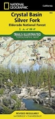
National Geographic’s Trails Illustrated map of Crystal Basin and Silver Fork covers the Eldorado National Forest, from its northern boundary with Tahoe National Forest to its southern boundary with Stanislaus National Forest. The map provides both unmatched detail and valuable information for outdoor enthusiasts exploring this part of California’s Sierra Nevada. Expertly researched and created in partnership with the U.S. Forest Service and others, this map features key points of interest including Mokelumne and Desolation Wildernesses, Hell Hole and Union Valley Reservoirs, Silver Lake and Kirkwood Ski Area. An informative summary of each wilderness area, safety tips, including a special section on bear safety tips, recreation tips and agency contact information are included as well.
The area's many trails are clearly marked and color coded according to their designated usage, whether you’re exploring on foot, horseback, bike, or motorized vehicle. Trail mileage between intersections along with contour lines and elevations will help you choose the path that’s right for you. The Pony Express National Historic Trail that bisects the area is highlighted along with the California National Historic Trail, Pacific Crest Trail and Rubicon OHV Trail. Carson Pass Scenic Byways is noted for those wishing to take in the scenery by car. The area is full of water and land recreation areas all of which are highlighted on the map. Some of the many recreation features include: snowmobile trails, ski areas, sno-parks, fishing and boat access, campgrounds and RV camping, scenic viewpoints and wildlife viewing areas.
Every Trails Illustrated map is printed on "Backcountry Tough" waterproof, tear-resistant paper. A full UTM grid is printed on the map to aid with GPS navigation.
Other features found on this map include: Desolation Wilderness, Eldorado National Forest, Mokelumne Wilderness, Mosquito Ridge, Stanislaus National Forest, Tahoe National Forest, Union Valley Reservoir.
Map Scale = 1:63,360Sheet Size = 37.75" x 25.5"Folded Size =Informazioni dettagliate del libro - Crystal Basin/silver Fork/eldorado National Forest
EAN (ISBN-13): 9781566952644
ISBN (ISBN-10): 1566952646
Anno di pubblicazione: 2009
Editore: National Geographic Maps
2 Pagine
Lingua: eng/Englisch
Libro nella banca dati dal 2010-06-08T09:45:36+02:00 (Zurich)
Pagina di dettaglio ultima modifica in 2022-10-12T16:48:08+02:00 (Zurich)
ISBN/EAN: 9781566952644
ISBN - Stili di scrittura alternativi:
1-56695-264-6, 978-1-56695-264-4
Stili di scrittura alternativi e concetti di ricerca simili:
Autore del libro : national geographic maps
Titolo del libro: eldorado, forest forest, fork fork
Dati dell'editore
Titolo: Eldorado National Forest - NATIONAL GEOGRAPHIC Trails Illustrated Californien
Editore: National Geographic Maps
Lingua: Inglese
9,99 € (DE)
10,30 € (AT)
Not available (reason unspecified)
CB; GEF; Karten, Globen / Reisen/Karten, Stadtpläne, Atlanten/Nordamerika, Mittelamerika; Landkarten und Atlanten; Nordamerika (USA und Kanada)
Altri libri che potrebbero essere simili a questo:
Ultimo libro simile:
0749717009851 Yosemite National Park: National Geographic Trails Illustrated Californien: Outdoor Recreation Map. Hiking Trails, Trail Mileages, High Sierra Camps, ... Geographic Trails Illustrated Map, Band 206) (National Geographic Maps)
- 0749717009851 Yosemite National Park: National Geographic Trails Illustrated Californien: Outdoor Recreation Map. Hiking Trails, Trail Mileages, High Sierra Camps, ... Geographic Trails Illustrated Map, Band 206) (National Geographic Maps)
- 0749717009844 Sequoia / Kings Canyon: National Geographic Trails Illustrated Californien: Waterproof. Tear-resistent (National Geographic Trails Illustrated Map, Band 205) (National Geographic Society (U. S.))
< Per archiviare...