
2021, ISBN: 1566954703
[EAN: 9781566954709], Neubuch, [SC: 2.9], [PU: NATL GEOGRAPHIC MAPS Mrz 2021], TRAVEL - GENERAL; / UNITED STATES WEST MOUNTAIN (AZ, CO, ID, MT, NM, NV, UT, WY); MAPS & ROAD ATLASES (SEE A… Altro …
| ZVAB.com Smartbuy, Einbeck, Germany [82220461] [Rating: 5 (von 5)] NEW BOOK. Costi di spedizione: EUR 2.90 Details... |

2021, ISBN: 1566954703
[EAN: 9781566954709], Neubuch, [SC: 0.0], [PU: NATL GEOGRAPHIC MAPS Mrz 2021], TRAVEL - GENERAL; / UNITED STATES WEST MOUNTAIN (AZ, CO, ID, MT, NM, NV, UT, WY); MAPS & ROAD ATLASES (SEE A… Altro …
| ZVAB.com AHA-BUCH GmbH, Einbeck, Germany [51283250] [Rating: 5 (von 5)] NEW BOOK. Costi di spedizione:Versandkostenfrei. (EUR 0.00) Details... |
2021, ISBN: 1566954703
[EAN: 9781566954709], Neubuch, [PU: NATL GEOGRAPHIC MAPS Mrz 2021], TRAVEL - GENERAL; / UNITED STATES WEST MOUNTAIN (AZ, CO, ID, MT, NM, NV, UT, WY); MAPS & ROAD ATLASES (SEE ALSO REFEREN… Altro …
| AbeBooks.de Smartbuy, Einbeck, Germany [82220461] [Rating: 5 (von 5)] NEW BOOK. Costi di spedizione: EUR 2.90 Details... |

2021, ISBN: 1566954703
[EAN: 9781566954709], Neubuch, [PU: NATL GEOGRAPHIC MAPS], TRAVEL - GENERAL UNITED STATES WEST MOUNTAIN (AZ, CO, ID, MT, NM, NV, UT, WY) MAPS & ROAD ATLASES (SEE ALSO REFERENCE ATLASES, G… Altro …
| AbeBooks.de moluna, Greven, Germany [73551232] [Rating: 4 (von 5)] NEW BOOK. Costi di spedizione:Versandkostenfrei. (EUR 0.00) Details... |

2012, ISBN: 9781566954709
Trails Illustrated National Parks, Karte/Globus, Karte (gefalzt), 2021st ed. [PU: National Geographic Maps], National Geographic Maps, 2012
| lehmanns.de Costi di spedizione:Versand in 7-10 Tagen. (EUR 0.00) Details... |

2021, ISBN: 1566954703
[EAN: 9781566954709], Neubuch, [SC: 2.9], [PU: NATL GEOGRAPHIC MAPS Mrz 2021], TRAVEL - GENERAL; / UNITED STATES WEST MOUNTAIN (AZ, CO, ID, MT, NM, NV, UT, WY); MAPS & ROAD ATLASES (SEE A… Altro …


2021, ISBN: 1566954703
[EAN: 9781566954709], Neubuch, [SC: 0.0], [PU: NATL GEOGRAPHIC MAPS Mrz 2021], TRAVEL - GENERAL; / UNITED STATES WEST MOUNTAIN (AZ, CO, ID, MT, NM, NV, UT, WY); MAPS & ROAD ATLASES (SEE A… Altro …
2021
ISBN: 1566954703
[EAN: 9781566954709], Neubuch, [PU: NATL GEOGRAPHIC MAPS Mrz 2021], TRAVEL - GENERAL; / UNITED STATES WEST MOUNTAIN (AZ, CO, ID, MT, NM, NV, UT, WY); MAPS & ROAD ATLASES (SEE ALSO REFEREN… Altro …

2021, ISBN: 1566954703
[EAN: 9781566954709], Neubuch, [PU: NATL GEOGRAPHIC MAPS], TRAVEL - GENERAL UNITED STATES WEST MOUNTAIN (AZ, CO, ID, MT, NM, NV, UT, WY) MAPS & ROAD ATLASES (SEE ALSO REFERENCE ATLASES, G… Altro …
2012, ISBN: 9781566954709
Trails Illustrated National Parks, Karte/Globus, Karte (gefalzt), 2021st ed. [PU: National Geographic Maps], National Geographic Maps, 2012
Dati bibliografici del miglior libro corrispondente

| Autore: | |
| Titolo: | |
| ISBN: |
• Waterproof • Tear-Resistant • Topographic Map
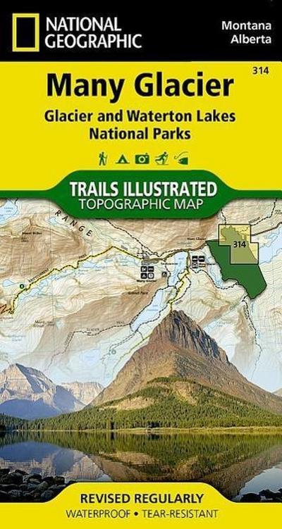
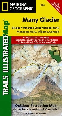
Created in partnership with local land management agencies, National Geographic's Trails Illustrated map of Many Glacier, Glacier and Waterton Lakes National Parks offers unparalleled detail for outdoor enthusiasts exploring the pristine landscapes contained within these two spectacular parks. This expertly researched map features key areas of interest including Many Glacier, Upper Kintia Lake, Rising Sun, Saint Mary Lake, Belly River, and the Waterton Lakes.
The Many Glacier map can guide you off the beaten path and back again with hundreds of miles of mapped trails including portions of the Pacific Northwest and Continental Divide trails. The map base includes contour lines and elevations for summits, passes and many lakes. Helpful information about recreation activities available in the parks, regulations, and snow and water hazards are included as well. Recreation features are clearly marked, including campgrounds, mountain bike trails, waterfalls, picnic areas, and horse rental locations.
Every Trails Illustrated map is printed on "Backcountry Tough" waterproof, tear-resistant paper. A full UTM grid is printed on the map to aid with GPS navigation.
Other features found on this map include: Glacier, Lake Sherburne, Lewis Range, Livingston Range, Lower Saint Mary Lake, Mount Cleveland, Saint Mary Lake, Upper Waterton Lake.
Map Scale = 1:50,000Sheet Size = 37.75" x 25.5"Folded Size = 4" x 7.5"Informazioni dettagliate del libro - Many Glacier, Glacier National Park
EAN (ISBN-13): 9781566954709
ISBN (ISBN-10): 1566954703
Copertina rigida
Copertina flessibile
Anno di pubblicazione: 2010
Editore: National Geographic Maps
2 Pagine
Peso: 0,092 kg
Lingua: eng/Englisch
Libro nella banca dati dal 2009-07-01T19:12:07+02:00 (Zurich)
Pagina di dettaglio ultima modifica in 2024-01-17T12:19:42+01:00 (Zurich)
ISBN/EAN: 9781566954709
ISBN - Stili di scrittura alternativi:
1-56695-470-3, 978-1-56695-470-9
Stili di scrittura alternativi e concetti di ricerca simili:
Autore del libro : national geographic maps, trail
Titolo del libro: many glacier, national geographic 2009, parks canada, montana recreation map, national geographic englisch
Altri libri che potrebbero essere simili a questo:
Ultimo libro simile:
9781566951777 Glacier, Waterton Lakes National Parks, Montana, USA/Alberta, Canada (National Geographic Maps)
< Per archiviare...