
ISBN: 9781566953276
This map includes Arches National Park, The Highlands, Little Valley, Devils Garden, Lost Spring Canyon Wilderness area, Negro Bill Wilderness area, Scott M. Matheson Wetlands Preserve, C… Altro …
| ebay.de loveourprices2 97.9, Zahlungsarten: Paypal, APPLE_PAY, Visa, Mastercard, American Express. Costi di spedizione:Versand zum Fixpreis, [SHT: Expressversand], GL3 *** Gloucester, [TO: Großbritannien, Antigua und Barbuda, Österreich, Belgien, Bulgarien, Republik Kroatien, Zypern, Tschechische Republik, Dänemark, Estland, Finnland, Frankreich, Deutschland, Griechenland, Ungarn, Irland, Italien, Lettland, Litauen, Luxemburg, Malta, Niederlande, Polen, Portugal, Rumänien, Slowakei, Slowenien, Spanien, Schweden, Australien, USA, Bahrain, Kanada, Brasilien, Japan, Neuseeland, China, Israel, Hongkong, Norwegen, Indonesien, Malaysia, Mexiko, Singapur, Südkorea, Schweiz, Taiwan, Thailand, Bangladesch, Belize, Bermuda, Bolivien, Barbados, Brunei Darussalam, Kaimaninseln, Dominica, Ecuador, Ägypten, Guernsey, Gibraltar, Guadeloupe, Grenada, Französisch-Guayana, Island, Jersey, Jordanien, Kambodscha, St. Kitts und Nevis, St. Lucia, Liechtenstein, Sri Lanka, Macau, Monaco, Malediven, Montserrat, Martinique, Nicaragua, Oman, Pakistan, Peru, Paraguay, Réunion, Turks- und Caicosinseln, Aruba, Saudi-Arabie. (EUR 9.96) Details... |

ISBN: 9781566953276
[ED: Karte], [PU: National Geographic Maps], Neuware - This map includes Arches National Park, The Highlands, Little Valley, Devils Garden, Lost Spring Canyon Wilderness area, Negro Bill … Altro …
| booklooker.de |

2012, ISBN: 1566953278
This map includes Arches National Park, The Highlands, Little Valley, Devils Garden, Lost Spring Canyon Wilderness area, Negro Bill Wilderness area, Scott M. Matheson Wetlands Preserve, C… Altro …
| Weltbild.de Nr. 50003847. Costi di spedizione:, 2-5 Werktage, DE. (EUR 0.00) Details... |

2012, ISBN: 9781566953276
Trails Illustrated National Parks, Karte/Globus, Karte (gefalzt), 2022nd ed. This map includes Arches National Park, The Highlands, Little Valley, Devils Garden, Lost Spring Canyon Wilder… Altro …
| lehmanns.de Costi di spedizione:sofort lieferbar. (EUR 0.00) Details... |
2012, ISBN: 1566953278
Karte mit neuen Wanderwegen und Campingplätzen Medien Karte (im Sinne von Landkarte) Buch, 1 Seiten, Medien > Bücher, National Geographic Maps, 2012
| Weltbild.de Nr. 50003847. Costi di spedizione:, 2-5 Werktage, DE. (EUR 0.00) Details... |


ISBN: 9781566953276
This map includes Arches National Park, The Highlands, Little Valley, Devils Garden, Lost Spring Canyon Wilderness area, Negro Bill Wilderness area, Scott M. Matheson Wetlands Preserve, C… Altro …

ISBN: 9781566953276
[ED: Karte], [PU: National Geographic Maps], Neuware - This map includes Arches National Park, The Highlands, Little Valley, Devils Garden, Lost Spring Canyon Wilderness area, Negro Bill … Altro …

2012
ISBN: 1566953278
This map includes Arches National Park, The Highlands, Little Valley, Devils Garden, Lost Spring Canyon Wilderness area, Negro Bill Wilderness area, Scott M. Matheson Wetlands Preserve, C… Altro …
2012, ISBN: 9781566953276
Trails Illustrated National Parks, Karte/Globus, Karte (gefalzt), 2022nd ed. This map includes Arches National Park, The Highlands, Little Valley, Devils Garden, Lost Spring Canyon Wilder… Altro …
2012, ISBN: 1566953278
Karte mit neuen Wanderwegen und Campingplätzen Medien Karte (im Sinne von Landkarte) Buch, 1 Seiten, Medien > Bücher, National Geographic Maps, 2012
Dati bibliografici del miglior libro corrispondente
| Autore: | |
| Titolo: | |
| ISBN: |
• Waterproof • Tear-Resistant • Topographic Map
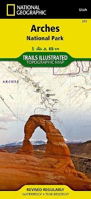
With over 2,000 natural stone arches and hundreds of other extraordinary geological formations, Arches National Park is a red rock wonderland. National Geographic’s Trails Illustrated map of the park combines unmatched detail with helpful information to offer an invaluable tool for making the most of your visit to this iconic region. Created in partnership with local land management agencies, this expertly researched map features key areas of interest including Devils Garden, the Windows Section, Sand Flats Recreation Area, the Sovereign area, and Wolfe Ranch. The print version of the map includes fascinating information about the park’s geology, archeology, history, and culture, as well as contact information and regulations.
The trails are clearly marked and mileage between intersections is provided. River mileage on the Colorado River is noted as well, for those exploring by boat. Trail and road summaries provide the location, starting point, duration, and difficulty for a variety of suggested routes. Mountain bike trails are color-coded based on degree of difficulty, and motorcycle and ATV trail use is clearly noted. The map base includes contour lines and elevations for summits. Some of the many recreation features include interpretive trails, campgrounds, river access, picnic areas, and points of interest.
Every Trails Illustrated map is printed on "Backcountry Tough" waterproof, tear-resistant paper. A full UTM grid is printed on the map to aid with GPS navigation.
Other features found on this map include: Arches National Park, Salt Valley.
Map Scale = 1:35,000Sheet Size = 25.5" x 37.75"Folded Size = 4.25" xInformazioni dettagliate del libro - Arches National Park
EAN (ISBN-13): 9781566953276
ISBN (ISBN-10): 1566953278
Copertina rigida
Copertina flessibile
Anno di pubblicazione: 2005
Editore: National Geographic Maps
2 Pagine
Peso: 0,136 kg
Lingua: Englisch
Libro nella banca dati dal 2008-12-01T09:30:57+01:00 (Zurich)
Pagina di dettaglio ultima modifica in 2024-01-26T12:38:58+01:00 (Zurich)
ISBN/EAN: 9781566953276
ISBN - Stili di scrittura alternativi:
1-56695-327-8, 978-1-56695-327-6
Stili di scrittura alternativi e concetti di ricerca simili:
Autore del libro : mcnally, rand, national geographic maps
Titolo del libro: arches, arch, best national geographic, utah, park, off the map, national geographic maps, arche, national geographic englisch
Dati dell'editore
Titolo: Arches National Park - National Geographic Trails Illustrated Utah
Editore: National Geographic Maps
Lingua: Inglese
9,99 € (DE)
10,30 € (AT)
Not available (reason unspecified)
CB; GEF; Karten, Globen / Reisen/Karten, Stadtpläne, Atlanten/Nordamerika, Mittelamerika; Landkarten und Atlanten; Nordamerika (USA und Kanada)
Altri libri che potrebbero essere simili a questo:
Ultimo libro simile:
0749717017603 Kenai National Wildlife Refuge Map: Trails Illustrated Other Rec. Areas (National Geographic Trails Illustrated Map) (National Geographic Maps)
- 0749717017603 Kenai National Wildlife Refuge Map: Trails Illustrated Other Rec. Areas (National Geographic Trails Illustrated Map) (National Geographic Maps)
- 0749717002630 Grand Canyon West, AZ: NATIONAL GEOGRAPHIC Trails Illustrated National Parks: Outdoor Recreation Map. Grand Canyon National Park Arizona, USA (National Geographic Trails Illustrated Map, Band 263) (National Geographic Maps)
- Denali National Park and Preserve (Trails Illustrated Map #222) (Ti - National Parks) by National Geographic Maps 4th (fourth) Edition (7/1/2007) (Natl Geographic Society Maps)
< Per archiviare...