
ISBN: 9781566953283
• Waterproof • Tear-Resistant • Topographic MapDenali National Park and Preserve covers a staggering six million acres of truly wild and pristine wilderness, bisected by a … Altro …
| BarnesandNoble.com new in stock. Costi di spedizione:zzgl. Versandkosten., Costi di spedizione aggiuntivi Details... |

Denali National Park and Preserve - nuovo libro
2013, ISBN: 1566953286
[EAN: 9781566953283], Neubuch, [PU: National Geographic Maps], TRAVEL - GENERAL SPORTS & RECREATION HIKING UNITED STATES WEST PACIFIC (AK, CA, HI, OR, WA) MAPS ROAD ATLASES (SEE ALSO REFE… Altro …
| AbeBooks.de moluna, Greven, Germany [73551232] [Rating: 4 (von 5)] NEW BOOK. Costi di spedizione:Versandkostenfrei. (EUR 0.00) Details... |

2012, ISBN: 1566953286
Karte mit neuen Wanderwegen und Campingplätzen Medien Karte (im Sinne von Landkarte) Buch, 1 Seiten, Medien > Bücher, National Geographic Maps, 2012
| Weltbild.de Nr. 50003862. Costi di spedizione:, 2-5 Werktage, DE. (EUR 0.00) Details... |

National Geographic Trails Illustrated Map Denali National Park & Preserve, Alaska, USA - nuovo libro
ISBN: 9781566953283
Karte mit neuen Wanderwegen und Campingplätzen Landkarten, National Geographic Maps
| Buecher.de Nr. 32893039. Costi di spedizione:, Versandfertig in über 4 Wochen, DE. (EUR 0.00) Details... |

Denali National Park And Preserve - nuovo libro
2012, ISBN: 9781566953283
Trails Illustrated National Parks, Karte/Globus, Karte (gefalzt), 2022nd ed. [PU: National Geographic Maps], National Geographic Maps, 2012
| lehmanns.de Costi di spedizione:sofort lieferbar. (EUR 0.00) Details... |

Denali National Park and Preserve Trails Illustrated Author - nuovo libro
ISBN: 9781566953283
• Waterproof • Tear-Resistant • Topographic MapDenali National Park and Preserve covers a staggering six million acres of truly wild and pristine wilderness, bisected by a … Altro …

National Geographic Maps:
Denali National Park and Preserve - nuovo libro2013, ISBN: 1566953286
[EAN: 9781566953283], Neubuch, [PU: National Geographic Maps], TRAVEL - GENERAL SPORTS & RECREATION HIKING UNITED STATES WEST PACIFIC (AK, CA, HI, OR, WA) MAPS ROAD ATLASES (SEE ALSO REFE… Altro …

2012
ISBN: 1566953286
Karte mit neuen Wanderwegen und Campingplätzen Medien Karte (im Sinne von Landkarte) Buch, 1 Seiten, Medien > Bücher, National Geographic Maps, 2012

National Geographic Trails Illustrated Map Denali National Park & Preserve, Alaska, USA - nuovo libro
ISBN: 9781566953283
Karte mit neuen Wanderwegen und Campingplätzen Landkarten, National Geographic Maps
Denali National Park And Preserve - nuovo libro
2012, ISBN: 9781566953283
Trails Illustrated National Parks, Karte/Globus, Karte (gefalzt), 2022nd ed. [PU: National Geographic Maps], National Geographic Maps, 2012
Dati bibliografici del miglior libro corrispondente

| Autore: | |
| Titolo: | |
| ISBN: |
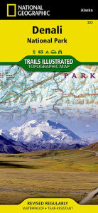
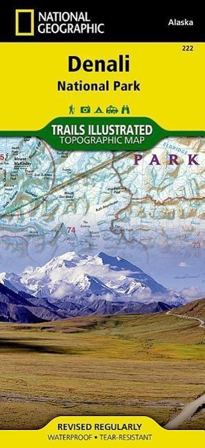
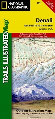
• Waterproof • Tear-Resistant • Topographic Map
Denali National Park and Preserve covers a staggering six million acres of truly wild and pristine wilderness, bisected by a single road. The crown jewel of the park is the towering 20,320 foot Mount McKinley, North America’s tallest peak. Expertly researched and created in partnership with local land management agencies, National Geographic’s Trails Illustrated map of Denali National Park provides an unparalleled tool for exploring this remarkable region. Key areas of interest featured on this map include Denali State Park; Kroto, Moose Creek, and Lake Creek recreation rivers; Lake Minchumina; and the Kantishna Mining District. The print version of the map includes a detailed inset of the park entrance and headquarters.
If you wish to camp in the park, a chart of campground information that includes the distance from the entrance, number and type of spaces, facilities, access, and contact information for making your reservations will help you plan your stay. Private vehicle travel in the park is limited, but this map’s coverage of the shuttle bus system will ensure you have the knowledge you need to access the entire park. Helpful information about regulations, avoiding close encounters with bears, hiking in the Kantishna Mining District, and safety tips, as well as clearly marked campgrounds, rental cabins, bush airstrips, trailheads, and more will help you enjoy all the park has to offer. The map base includes contour lines and elevations for summits, passes and many lakes.
Every Trails Illustrated map is printed on "Backcountry Tough" waterproof, tear-resistant paper. A full UTM grid is printed on the map to aid with GPS navigation.
Other features found on this map include: Bear Creek, Birch Creek, Broad Pass, Browne Tower, Chelatna Lake, Chulitna River, Chunilna Creek, Dall Glacier, Denali National Park, Denali National Preserve, East Buttress, Eldridge Glacier, Foraker River, Herron River, Kahiltna Glacier, Lacuna Glacier, Lake Minchumina, McKinley River, Moose Creek, Mount Foraker, Mount Hunter, Mount Mather, Mount McKinley, Muldrow Glacier, Portage Creek, Ruth Glacier, Sheep River, South Buttress, Stephan Lake, Talkeetna River, Tokositna Glacier, Yanert Fork, Yentna Glacier.
Map Scale = 1:225,000Sheet Size = 25.5" x 37.75"Folded Size = 4.2Informazioni dettagliate del libro - Denali National Park and Preserve Trails Illustrated Author
EAN (ISBN-13): 9781566953283
ISBN (ISBN-10): 1566953286
Copertina rigida
Copertina flessibile
Anno di pubblicazione: 2009
Editore: Trails Illustrated Core >9
2 Pagine
Peso: 0,089 kg
Lingua: eng/Englisch
Libro nella banca dati dal 2007-07-02T14:37:34+02:00 (Zurich)
Pagina di dettaglio ultima modifica in 2024-04-04T17:40:51+02:00 (Zurich)
ISBN/EAN: 1566953286
ISBN - Stili di scrittura alternativi:
1-56695-328-6, 978-1-56695-328-3
Stili di scrittura alternativi e concetti di ricerca simili:
Autore del libro : national geographic maps, trail
Titolo del libro: 222, gps, best national geographic, looking for alaska, usa, park, national geographic maps, denali map, national geographic englisch, trails
Dati dell'editore
Titolo: Denali National Park & Preserve - National Geographic Trails Illustrated Alaska
Editore: National Geographic Maps
Lingua: Inglese
9,99 € (DE)
10,30 € (AT)
Not available (reason unspecified)
CB; GEF; Karten, Globen / Reisen/Karten, Stadtpläne, Atlanten/Nordamerika, Mittelamerika; Landkarten und Atlanten; Nordamerika (USA und Kanada)
Altri libri che potrebbero essere simili a questo:
Ultimo libro simile:
0749717002630 Grand Canyon West, AZ: NATIONAL GEOGRAPHIC Trails Illustrated National Parks: Outdoor Recreation Map. Grand Canyon National Park Arizona, USA (National Geographic Trails Illustrated Map, Band 263) (National Geographic Maps)
- 0749717002630 Grand Canyon West, AZ: NATIONAL GEOGRAPHIC Trails Illustrated National Parks: Outdoor Recreation Map. Grand Canyon National Park Arizona, USA (National Geographic Trails Illustrated Map, Band 263) (National Geographic Maps)
- 0749717009905 Acadia National Park, ME: National Geographic Trails Illustrated USA Nordosten: Outdoor Recreation Map. Isle Au Haut, Mount Desert Island, and ... Geographic Trails Illustrated Map, Band 212) (National Geographic Maps)
- 9781566952897 Big Bend National Park Trails Illustrated Author (National Geographic Maps)
- Durango, Cortez (National Geographic Trails Illustrated Map) by National Geographic Maps - Trails Illustrated (2007-01-01) (National Geographic Maps - Trails Illustrated)
< Per archiviare...